Showing posts with label Favorite places. Show all posts

Tuesday, April 17, 2012

Kalpathi


Also known as Dakshin Kasi or the 'Varanasi of the South is an early Tamil Brahmin settlement (agraharam) in the Palakkad District, 
Kalpathi is very famous for Kalpathi Ratholsavam, Temple car festival held annually at the Sri Visalakshi Sametha Sri Viswanatha Swamy temple where the deity is Lord Siva (Lord Viswanatha). The biggest festival of this place is the annual car festival(kalpathy theru). This is celebrated in a very grand manner.

Kalpathy is located 3 km from Palakkad town and consists of Old Kalpathy and New Kalpathy.
On the eastern side of Sree Viswanatha Swamy Temple lies the New Kalpathy Village which consisted of homes built mostly of thatched roofing. It belonged perhaps to the last batch of Tamil Brahmin migrants. Harassed by frequent fire, loss of life and property, the villagers consecrated a temple dedicated to Lord Maha Ganapathy to ward off "Sivadrishti". The idol of Mahaganapathy resting under a Banyan tree near a tank lying on the eastern side of this village (Manthakkara) was installed facing Lord Shiva (in Sree Viswanatha temple). 
The residents of this village were well known scholars of Vedas & Shastras and purohits well versed in their profession. Most of the surrounding villages of Palakkad town used to depend on them for conducting the Vedic rituals. Any doubt on observations of rituals and interpretations of sastras used to be debated and decided here. This village is also the birth place of many professionals, musicians, scientists and men of letters.
New Kalpathy village was a citadel of Vedic culture and Sanathana dharma. It has produced numerous scholars of Vedas and Vedangas. They are still being remembered by villagers with reverence and devotion. Their scholarship used to be recognized by both Shringeri and Kanchi Sankaracharya Mutts. This village sent the largest contingent of delegates of Veda scholars to attend the All India Sanathana Conference held at Kasi during 1932-33 
In the recent past many new housing colonies have sprung up in and around Kalpathi. One such colony is Kailas Nagar where some of the eminent citizens of Palakkad have built their homes. Kailas Nagar is also has the distinction of running a school for special children called "Chaitanya School". Mrs. BhagyaLaxmi of Kailas Nagar has taken keen interest in establishing this school and nurturing it.
How to get there
Nearest town: Palakkad - 3 km
Nearest railway station: Olavakot-Palakkad - 1 km
Nearest airport: Coimbatore - 55 km


Reference:

Tuesday, March 6, 2012

Jain Temple of Jainimedu


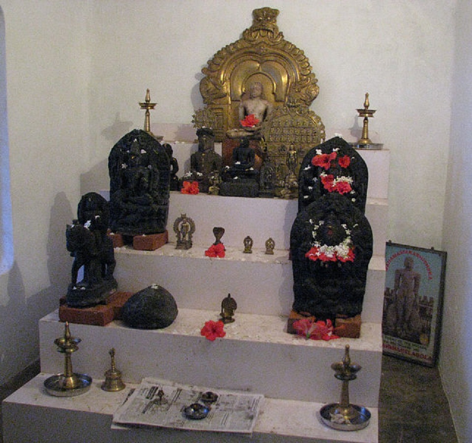
Situated on the western border of Palakkad town and not far from the railway station, this is an historic Jain Temple. The area around the temple is known as Jainimedu. This is one of the few places in Kerala where vestiges of Jainism in Kerala have survived without substantial damage.
The granite walls are devoid of decoration. The temple, 32 feet (9.8 m) long and 20 feet (6.1 m) wide, consists of four divisions with images of Jain Thirthankaras and Yakshinis in three of them.

 Kumaran Asan wrote his monumental poem Veena Poovu (the fallen flower) at a Jain house here during his brief stay with his master Sri. Narayana Guru.

Jainism has had a continued presence in Kerala since pre-Christian times with Jainism in Kerala enjoying an extensive heritage and history.

At present, Jainism in Kerala has a very small following, mainly from the original Jains of Kerala and the Gujarati Jain business community, to be found in Kochi and Calicut. Most of the Shwetambar followers are living in Mattancherry (Kochi) and Digambar community families are residents of Ernakulam (Kochi)

Route:In between Vadakkunthara  to palakkad town


References:

Silent Valley National Park


Silent Valley National Park (Malayalam: (സൈലന്‍റ് വാലീ നാഷണല്‍ പാര്‍ക്ക്), is located in the Nilgiri Hills, Palakkad District in Kerala, South India. The area in this national park was historically explored in 1847 by the botanist Robert Wight and is associated with Hindu legend.

The park is one of the last undisturbed tracts of South Western Ghats montane rain forests and tropical moist evergreen forest in India. Contiguous with the proposed Karimpuzha National Park to the north and Mukurthi National Park to the north-east, it is the core of the Nilgiri International Biosphere Reserve , and is part of The Western Ghats World Heritage Site, Nilgiri Sub-Cluster under consideration by UNESCO.

The visitors' centre for the park is at Sairandhri.
The area is locally known as "Sairandhrivanam" literally, in Malayalam: Sairandhri's Forest. In local Hindu legend, Sairandhri is Draupadi, the polyandrous wife of the five Pandavas, who disguised herself as Sairandhri, queen Sudeshna's assistant, while they were in exile.The Pandavas, deprived of their kingdom, set out on a 14-year exile. They wandered south, into what is now Kerala, until one day they came upon a magical valley where rolling grasslands met wooded ravines, a deep green river bubbled its course through impenetrable forest, where at dawn and twilight the tiger and elephant would drink together at the water's edge, where all was harmonious and man unknown. Beside that river, in a cave on a hill slope, the Pandavas halted.
Silent Valley is home to the largest population of Lion-tailed Macaque, an endangered species of Primate. It has many rare type of birds,mammals,trees,insects etc..


The Kuntipuzha River drains the entire 15 km length of the park from north to south into the Bharathapuzha River. Kuntipuzha River divides the park into a narrow eastern sector of width 2 kilometers and a wide western sector of 5 kilometers. The river is characterized by its crystal clear and perennial nature. The main tributaries of the river, kunthancholapuzha, Karingathodu, Madrimaranthodu, Valiaparathodu and Kummaathanthodu originate on the upper slopes of the eastern side of the valley. The river is uniformly shallow, with no flood plains or meanders. Its bed falls from 1,861 m to 900 m over a distance of 12 km, the last 8 km being particularly level with a fall of only 60 m. Kuntipuzha is one of the less torrential rivers of the Western Ghats, with a pesticide-free catchment area.


How to Reach
The nearest Rail head is Palakkad Junction (Olavacode) which is nearly 60 Kms away from the base camp of the National Park, Mukkali .
Shornur junction , another  railhead is about 75 Km from the base camp of the National Park, Mukkali.
Coimbatore Junction in Tamil Nadu is also 45 km away from Mukkali, the base camp.
Nearest Air Ports are Cochin (135KM), Coimbatore (55 KM) and Calicut (80KM).
By road
From East: Palakkad (60 KM) and Coimbatore (45 KM)
From South : Thrissur (115KM) and Shornur (75 KM)
From North : Calicut (120KM)


Reference:


Parambikulam Wildlife Sanctuary


Parambikulam Wildlife Sanctuary is a  Protected area in Chittur taluk in Palakkad district of Kerala state, South India. Established in 1973, it is in the Sungam range of hills between the Anaimalai Hills and Nelliampathy Hills. 
The Western Ghats, Anamalai Sub-Cluster, including all of Parambikulam Wildlife Sanctuary, is under consideration by the UNESCO World Heritage Committee for selection as a World Heritage Site. The sanctuary is the home of 4 different tribes of indigenous peoples including the Kadar, Malasar, Muduvar and Mala Malasar settled in six colonies.
 Parambikkulam Wildlife Sanctuary was declared as part of the  Parambiculam Tiger Reserve on February 19, 2010.

Trekking in the forest is allowed with prior permission

Boating can be done at the reservoir. 


There is a tree-house in the Reserve Forest area in Thoonakkadavu, the headquarters of Parambikkulam, which has to be booked in advance.


The sanctuary has a variety of trees mainly teak, neem, sandalwood and rosewood. Even the oldest ever teak tree, Kannimara Teak exists here. It is about 450 years old and has an unbelievable girth of 6.8 metres and a height of 49.5 metres. It won the Mahavriksha Puraskar given by the Indian Government.which is said to be Asia’s largest, is here near Thoonakkadavu village.


The sanctuary has a rich diversity of animal life including: Mammals 39 species, Amphibians 16 sp., Birds 268 sp., Reptiles 61 sp., Fish 47 sp., Insects 1049 sp. and Butterflies 124 sp.

The Main attraction of this place is this rare mammal(Macaca silenus-സിംഹവാലൻ കുരങ്ങ്‌)


Parambikkulam is only accessible by road from Pollachi, Tamil Nadu. Palakkad to Pollachi is about 45 km; then Pollachi to Parambikkulam is about 65 km. The nearest railway station is at Pollachi and the nearest airport is at Coimbatore, Tamil Nadu, about 120 km via Palakkad.

References:

Nelliampathi


Known as the Ooty of Kerala, about 80 km from Palakkad. It is a hill station in the forest between a series of ridges cut off from one another by valleys of dark evergreen forests,It is beautiful place with lot of Tea and cofee Plantations,The Climate also will take us in to the heart of nature,whenever i feel to have some relaxation i used to be here,it has many spots to be viewed ,Seetharkundu("Suicide point"commonly says)Kesavan Para,Manpara,and waterfalls it is Awesome to be here bestowed by nature to the commons,i love this place 


 The journey to Nelliampathi itself is an experience. The only route is from Nemmara, from where the first town of Nelliampathi, namely Kaikatty junction, is at a distance of 26 km. At the 9th kilometer is the Pothundi Dam, which provides water for the rice fields in the surrounding area. The dam is at the foot of the Nelliampathi hills. From here, the road winds up for the next 17 km, with many hairpin turns on the way. Immediately after Pothundy dam, comes the government forest, where one can see massive teak trees. 


The road is very narrow and requires a skilled driver behind the wheel. On the way, one can see wild animals like monkey, deer and porcupine.

Pothundi Dam is an irrigation dam,The dam is unusual in being constructed without a conventional concrete core, which is employed in most earth dams to counteract the force exerted by high water pressure. The core is, instead, an unusual mixture of jaggery and quick lime.It is the second dam in Asia constructed without using cement mixture.The view of the Pothundy dam from the height is a breathtaking sight. There will be many waterfalls by the roadside during the rainy season.
Kesavanpara is home to the Nelliampathi mountains, and offers a panoramic view of the land below. It is near to Kaikatty. 
Seetharkundu("Suicide point"commonly says)

It offers a fantastic view of the valley below. The 1000 meter high waterfall is one of the major attractions.
It is believed that Rama, Lakshmana and Sita of the famous Hindu epic Ramayana lived in this place and Sita used to offer worship with the water from a small stream. Seetharkundu got its name from the legend that Sita Devi during the vanavasa period with Rama, took a bath here. The dams at Chulliyar and Meenkara and the town of Kollengode can be viewed from here, at a distance.

Manpara another view point ,
Some Beautiful Pictures,


Nearest Airports: Cochin International Airport and Coimbatore Airport
From Cochin Airport: Come to Thrissur - 30 km; take a taxi or bus from Thrissur bus stand to Nemmara - 48 km. From Coimbatore Airport: Come to Palakkad - 50 km; take a taxi or bus to Nemmara - 30 km. From Nemmara you can take a taxi or a four-wheeler vehicle (jeep) to Neliiampathi.
Nearest main railway stations: Palakkad, Thrissur and Coimbatore


References:


Monday, March 5, 2012

Malambuzha Dam and Gardens


Situated about 10 km from Palakkad Town, Malapuzha Dam was completed in 1955 and is the largest reservoir in Kerala. The spot is also known for its scenic beauty and sprawling gardens. It is one of the major attractions in this part of Kerala.
Malampuzha Dam has brought prosperity to the district, making Palakkad the `rice bowl of Kerala'. Paddy is cultivated in 50,000 acres  in two seasons each using waters from the Malampuzha dam.
The Malampuzha Garden and reservoir have a scenic setting with the forested hills of Western Ghats forming the backdrop, making it one of the foremost tourism centres in the State.
The dam across Malampuzha river has a total length of 2,069 metres. Of this, masonry dam has a length of 1,849 metres while the earthen dam covers the length of 220 metres. The catchment area of the dam is 147.63 km². Its storage capacity is 236.69 cubic metres. The full reservoir level of the dam is 115.06 m (375.15 ft)and Gross Storage at FRL is 226 mm3.
 The idea of constructing a dam at Malampuzha was mooted in 1914 by the then Madras Government. Palakkad was part of Madras presidency then. In March 1949, the then Public Works Minister K. Bhaktavalsalam laid the foundation stone for the construction of the dam. On October 9, 1955, the then Chief Minister, K. Kamaraj inaugurated it. 

Before the construction of the dam, the area was known as Punnppara, Chovankadu, Iduppady, Vadukampadam, Thanjikapallam, Karakkad, Thoopallam, Varani, Akkarakadu, Kadukkamkunnam, Aanakuzhykadu, Thampurattypotta, Aanamukkara, Pandipotta, Thekkumpadam and Koshavan Idukku. Now the entire area is known as Malampuzha. 
The dam was conceived as a multi-purpose project to provide water for irrigation, drinking, industries, power generation, fish farming and water transport.

One of the famous Sculpture by Kanayi Kunhiraman at Malampuzha Dam,whcich is very attractive and you will forget to take your eyes off


Kanayi Kunhiraman (Malayalam:കാനായി കുഞ്ഞിരാമന്‍ )
 born 25 July 1937) is a sculptor from Kuttamath in Hosdurg Taluk in Kasaragod district of Kerala state, India. He is the Former Chairman of the Lalit Kala Academy
Kunhiraman is the first sculptor recipient of the Raja Ravi Varma Award, which includes  1 lakh in cash, a citation and a statue, sculptured by Kunhiraman himself. It was conferred by Kerala's Chief Minister Oommen Chandy at Thiruvananthapuram.


References
http://en.wikipedia.org/wiki/Malampuzha_Dam
http://en.wikipedia.org/wiki/Palakkad#Etymology

Palakkad Fort


http://commons.wikimedia.org/wiki/File:Palakkad-Fort-outside-view.JPG

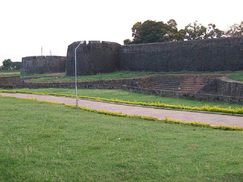
Fort dating from 1766, built by Hyder Ali of Mysore. In 1784, after a siege which lasted eleven days, the British Colonel Fullerton stormed the Fort. Later it fell into the hands of the Zamorin’s troops, but was recaptured by the British in 1790. This well-preserved fort is also known as Tipu's (Tipu Sultan, son of Hyder Ali) Fort.


There is a large ground between the Fort and the Palakkad Town hall, known as Kota Maidanam (Fort Grounds). The ground, which had once served as a stable for the elephants and horses of Tipu's army, is now used to stage cricket matches, exhibitions and public meetings. An open air auditorium called "Rappadi", currently under the preservation of the Archaeological Survey of India, is also located within the spacious grounds of the Fort. Additionally, there is a children's park on one side of the Fort.

There is a small Anjaneya (Lord Hanuman) temple inside the fort that attracts a number of devotees.
One of the rare picture by the uploader


http://commons.wikimedia.org/wiki/File:Palakkad_Fort-temple-inside.JPG

http://commons.wikimedia.org/wiki/File:Palakkad-Fort-inside-view22.JPG

The Palakkad Sub Jail is also located within the fort.And civil supplies office also functions inside
It is said that Hyder Ali had plan to build the famous Palakkad Fort here, before it is built in its present location. Granites and rocks are kept here for constructing the fort. But the plan was changed and the fort was constructed at Palakkad. The resulted massive plain land was used by the people of nearby villages as a market of ancient times. Since then this area is known as 'Kottachantha' of which 'Kotta' means Fort and 'Chantha' means Market in malayalam language


It is believed that the name of the next village Kottayi, is derived from the use 'Kottayilekkulla Vazhi/Vayi' meaning 'The way to Fort' which also strongly support Hyder Ali's plan to build the fort here. However, there are no disputes over the arguments on Kottachantha's historical importance connected to Palakkad Fort.


References:http://en.wikipedia.org/wiki/Palakkad_Fort
http://commons.wikimedia.org/wiki/Category:Palakkad_Fort